The moving map display I demonstrated in the forty-five minute video in A Moving Map Display Using OpenStreetMap (2021) was the result of playing back a dataset I had collected in 2020 during a test of a u-blox UBX-NEO-M8U, a relatively complex piece of kit that included not only a Global Navigation Satellite System (GNSS) receiver but also an integrated Inertial Measurement Unit (IMU). I wanted to capture a moving map video in real-time just to remind myself that it could be done, so this morning I did just that.
The Overview
You might recall from that prior article, my implementation consists of four components.
The Rover is either a GNSS receiver connected to a computer running my Hazer gpstool software to collect geolocation data in real-time, or a computer playing back such a dataset.
The Model is an OpenStreetMap (OSM) tile server that serves up graphical map segments and associated metadata via HTTP requests over TCP.
The View is your favorite modern web browser supporting JavaScript and HTML5 that renders the moving map using tiles fetched from the Model as it is steered by the Controller.
The Controller is a conduit that captures the datagrams of JSON data transmitted by the Rover over UDP and makes them available to the rest of the system via HTTP requests over TCP.

The Model, View, and Controller are all part my Tesoro project.
The Good Stuff
We'll start off with today's fifteen minute (14:49) video, captured on a display at my home base while I drove my Subaru WRX equipped with the Rover around the neighborhood. Feel free to skip around. (If the video doesn't show up for you, you can find it on YouTube. For best results, open the video up in a larger window, and select the High Definition version.)
The Test Setup
The Model was the same Raspberry Pi as before, running the OSM software stack as an Apache web application.
The View was my desktop Mac Mini with a Cinema Display, using QuickTime to capture the video from the Safari web browser running the Tesoro client-side movingmap JavaScript program.
The Controller was the Tesoro channel server-side JavaScript program running under Node.js on another Raspberry Pi. It is the same RPi I use as a Real-Time Kinematic (RTK) corrections server for Differential GNSS (DGNSS) for my Tumbleweed project.
The Rover consisted of a relatively inexpensive USB-connected receiver, a GlobalSat BU-353S4-5Hz, based on a SiRF Star IV chipset. (SiRF is a division of mobile phone chip maker Qualcomm). It was connected to a GPD MicroPC running Hazer's gpstool under Ubuntu MATE. The tiny palmtop computer was equipped with an external NovAtel MiFi USB730L LTE modem that it used to transmit its JSON datagrams containing geolocation data back to home base.
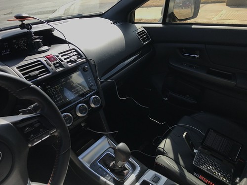
Here is the Rover sitting in the WRX during the test; the GPS receiver is at the far left on a mount on the dashboard, and the PC is sitting on the passenger seat at the far right with the LTE modem visible on its left side.
Here's a close up of the BU-353S4-5Hz receiver in my lab. The little USB dongle is not much larger than a wristwatch face, and includes the GPS receiver, the active (amplified) patch antenna, and the USB interface which provides both connectivity and power. It's magnetically mounted on a steel plate that serves as a ground plane, a reflective surface for GPS radio waves.

The GPD MicroPC, shown below on my lap bench with the LTE modem attached on its left side, is basically a pocket-sized ruggedized industrial PC. Although I don't do any touch typing on its chicklet keyboard, I really like the fact that the little Intel Celeron-equipped palmtop incorporates a lot of useful interfaces, including WiFi, an RJ45 Ethernet jack, and an RS232 serial port with a DB9 connector.

UDP vs. TCP
If you watch the video, and pay attention to the JavaScript console at the bottom, you will notice that the movingmap script occasionally reports missing JSON datagrams. This is typical of my experience in the field using LTE modems and the best effort User Datagram Protocol (UDP) to transmit geolocation updates to the home base. This causes the moving map display to briefly stall and then jump forward as it catches up to the real-time data.
As you might expect, using the guaranteed delivery Transmission Control Protocol (TCP) instead of UDP solves this problem. And indeed, my initial implementation years ago used TCP. But what I found during these kinds of real-time visualizations, especially in locations with spotty cellular reception, is that the display could lag many seconds behind real-time as the TCP/IP stack retransmitted lost packets. And once behind, it never caught up. In fact, it sometimes got progressively worse. It was far better to have the map pointer jump forward than to permanently and increasingly lag behind what was happening in meat-space.
I talked about this at length in Better Never Than Late (2017): in this particular real-time application, it is better to lose packets, or drop packets that arrive out of order, than it is to wait for the network stack to ensure perfect reliability. Besides, my Hazer software saves all the geolocation information on the Rover as a dataset of Comma Separated Values (CSV). So at worst, you can play back the dataset with perfect fidelity when the Rover returns to home base.
(Note: edited several times for corrections and clarity.)


3 comments:
A big Thank You to Todd Hoff who quoted this article in his excellent blog High Scalability (I subscribe to it in my RSS feed and check it every weekday while eating lunch): http://highscalability.com/blog/2021/3/17/stuff-the-internet-says-on-scalability-for-march-17th-2021.html
Hi.
Did you use RTK for your positioning, because it is not clear what you(rover) send to base? Or you simply send your position to home server to log?
Thank you for interesting post as usual.
The latter. My software supports RTK for its use with differential GNSS, and I've written in the past about using my stuff on a base station and a rover; I have a base station running 24x7 emitting RTK for corrections. But in this case, I just sent the Comma Separate Value (CSV) output of my software on the rover to home base using an LTE modem on the rover. Thanks for the question!
Post a Comment